


Cambodia's vast lost city: world's greatest pre-industrial site unearthed
01 Jul 2013
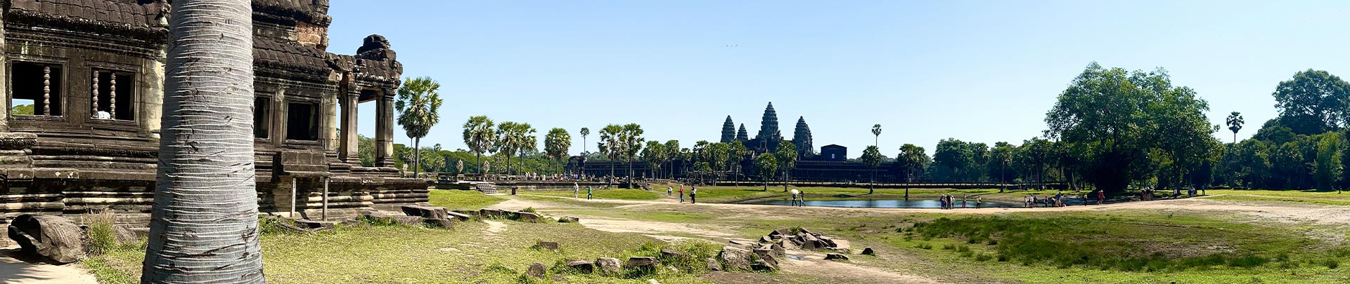
It's 7am at Angkor Wat and there's not a tourist in sight. It's blissfully quiet, the first clear June morning after two days of torrential rains. The only souls around are a small group of Buddhist pilgrims, lighting incense at the rear of the spectacular Khmer temple. The bleary-eyed early-risers, who woke in darkness to board tour buses to Angkor archaeological park for sunrise photo ops, have already trundled back to their breakfast buffets.
I'm not here for sightseeing, however, I'm heading further into the forest surrounding the stupendous temple complex with Australian archaeologist Dr Damian Evans to meet the archaeologists from Cambodia, the Philippines and the USA, who are working on new excavations.
The release this month by the US National Academy of Sciences of a report on the results of a high-tech survey of Khmer Empire sites, undertaken in April 2012, has rocked the archaeological world and captured travellers' imaginations.
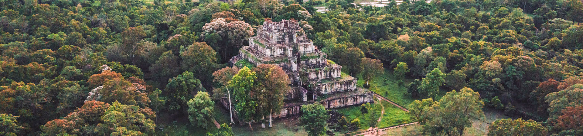
A monumental, sophisticated, densely populated urban landscape, which dates back more than 700 years, has been identified. It includes and connects Angkor cities such as Angkor Wat, Angkor Thom and Bayon, with the rarely visited medieval city ruins of Phnom Kulen, Beng Mealea and Koh Ker, over 100km away.
Srah Damrie, Siem Reap archaeology, Mount Kulen Srah Damrie, Siem Reap archaeology, Mount Kulen. Photograph: /Terence Carter
Evans was one of the report authors and the lead archaeologist and director of the project, which only became known outside local and archaeological circles with the release of the report this month.
As we make our way through dense vegetation, he explains how eight key archaeological groups, including the Cambodian government's Apsara Authority, which manages archaeological sites, collaborated on the project. It began with the survey using an airborne laser scanning instrument called Lidar, strapped to a helicopter, to search for ruins and other structures (the size of the area covered by the helicopter doing the survey was 320 sq km). Developed in the 1990s, it's only recently that the technology has matured to the level where it can penetrate dense vegetation and provide extremely detailed models of the forest floor.
"For archaeologists, these lumps and bumps that we see in the forest, each has a meaning," Evans explains, pointing out gentle mounds. "These are all the traces of the civilisation of the city associated with Angkor Wat, made of wood and thatch, that has disappeared. It's these contours that remain inscribed into the forest landscape we study."
Smoke wafts from the fires lit to keep mosquitoes at bay. Dotted between the mounds are several rectangular holes in the ground where Dr Miriam Stark from the University of Hawaii and her team are at work.
"We're really interested in understanding residence patterns, where and how people lived and who they were," Stark explains excitedly, showing me X-ray-like images of the area we're in. "Before, it took more than three intensive weeks of [preparation] before we knew where to dig. Now, with Lidar, it's as if you just peel a layer off and it's there!" With clipboards and pens in hand, the team records a wealth of discoveries, such as shards of Ming Dynasty ceramics.
Ta Prohm Temple, Siem Reap Ta Prohm Temple, Siem Reap. Photograph: Terence Cartere
Scholars have based their idea of all medieval cities around the world on European cities, explains Professor Roland Fletcher, director of the Greater Angkor Project. But now, it seems there was a colossal low-density urban sprawl here, a conurbation of different places with massive working citadels with enormous infrastructure. Remote temples cities like Koh Ker, 120km from Siem Reap, and Beng Mealea, 52km away, once thought of as isolated, would have been large outlying service centres for Angkor within a huge hinterland.
"This is a highly managed system, the most extensive pre-industrial city in the world," he says, though referring to its complexity rather than its size. "The Lidar results show there were three cities [here] at the end of the 9th century – the largest was on top of Mount Kulen, creating an [equivalent to] industrial 19th-century Britain."
The city is so enormous it is unlikely to ever exist as one excavated site, but tourism here is likely to increase. There's talk of a cutting-edge museum presenting the exciting new discoveries, new archaeological sites in the future, and greater interest in little-visited outlying temples already accessible to the public.
We decide to head to one of these Phnom Kulen, a site rarely visited by tourists, with just a few companies offering expeditions and treks there.
"Phnom Kulen is a sacred mountain, a holy place for Cambodians," Tat, our guide from Backyard Travel tells us en route. His ancestors called this place Mahendraparvata, or the Mountain of Indra, King of the Gods. "We call it the Mountain of the Lychees now. Look, you can see it here," he says, pointing to a long, low, flat plateau that barely rises above the palms, banana plants and rubber trees that skirt the road and hug the traditional stilted timber houses dotting the lush emerald-green countryside.
Siem Reap composite Carvings at Ta Nei Temple, Siem Reap and at Srah Damrie, Mount Kulen. Photograph: Terence Carter
Phnom Kulen may not be the dramatic mist-shrouded peak I imagined, yet the 492m-high, 8km-wide and 32km-long mountain is visible for the whole 90-minute drive north from Siem Reap to the foothills of Mount Kulen national park. We intend to hike to the summit, and the remains of the three-tiered temple of Prasat Rong Chen that marks the site where the Khmer Empire was founded in AD 802, when a Brahmin priest declared Jayavarman II universal monarch – just two years after Charlemagne was made Holy Roman Emperor – will be nothing less than dramatic.
Mahendraparvata was never really "lost" – the mountain has long been known as the location of the sandstone quarries that built Angkor's cities, as well as the source of water for a complex system that irrigated the vast empire. When we visit, people are wading in the River of A Thousand Lingas, a section of the stream boasting stone carvings on its floor. Villagers frequently stumble across finds, recently some bronze, copper and sandstone statues of Hindu gods Vishnu, Shiva and Lakshmi. But the Lidar survey confirmed that Mahendraparvata was part of a city, and much larger than suspected – maybe as big as present-day Phnom Penh.
We leave our air-conditioned four-wheel drive behind and soon we're bouncing along muddy tracks on the back of motorbikes behind guides familiar with the landmine-riddled mountainside, that was the last stronghold of the Khmer Rouge.
Workers on a dig at Angkor Wat Workers on a dig at Angkor Wat. Photograph: Terence Carter
They lead us towards the summit. It's a slow journey, over narrow, bumpy dirt trails – only the most intrepid travellers come here. We cross log bridges and ride straight through flowing streams. Scattered across the mountain are ruined, foliage-covered temples, ancient highway markers and, at Sras Damrei or Elephant Pond, massive statues of an elephant and lions. The thought that more sites like this could soon be discovered is thrilling.
Back in Siem Reap we take to the air in a helicopter to get a better idea of what this urban landscape might have looked like. Had I taken the flight two weeks' ago, I would have gasped at the magnificence of the isolated temple structures with their imposing walls and moats surrounded by forests. Now, I see patterns of bumps and lines on the vast floodplain as beautiful remnants of an immense, effervescent city that technology and archaeology are finally bringing to life.
While many believe this site will become one of Asia's greatest wonders, and tourism bodies are eager to see excavations progress quickly and more archaeological sites opened up to visitors, the extraordinary size of the area means work will be costly and take years. In the meantime, however, the intrepid can play at being Indiana Jones at undeveloped sites on Phnom Kulen, and temple cities such as Beng Mealea and Koh Ker – and let their imaginations run wild.
Sourced: Cambodia News
Sponsored News
More Cambodia Travel News
Cambodia Tours

Cambodia Day Tours

Angkor Temple Tours

Cambodia Classic Tours

Promotion Tours

Adventure Tours

Cycling Tours
Trip Planner
Useful Links
Travel Services
News & Media
Agency offering information about Cambodia on tourism, culture, history, visa, attractions, province guides, trip planner, hotels, flights, cars, tours, news, photo and online bookings.
#262D, Monivong Blvd., Sangkat Beung Raing, Khan Daun Penh.Click here to contact us.