
Rattanakiri - Cambodia Eco-ourism

Province Capital: 636 km. north - east of Phnom Penh
Area: 11,052 Square kilometers
Population: 94243 people (ethnic minority) represent 75.77% of the total.
Religion: Buddhism and Animism.
Accessibility: by land, car from Phnom Penh/Kratie/Steung Treng to Rattanakiri.
Major occupations: farming
Major products: gemstones & agriculture
Major industries: farming & tourism
Ratanakiri became a province of Kingdom of Cambodia in 1960 under King Norodom Sihanouk's reign. Banlung is the capital city of Ratanakiri, situated in the highland, along the National Road No19 from Ou porng Moan to the Vietnam border about 200 km. ( Ou´ porng Moan-Banlung is about 120km, Banlung-Vietnam 80k.m)
Ratanakiri is situated on the north - east plateau , 636 Km from Phnom Penh. It is bordering Vietnam on the east, Laos PDR on the North, Steung Treng on the West and Mondul Kiri on the South. There are two rivers crossing the province ( Sre Pork and Sresan River )
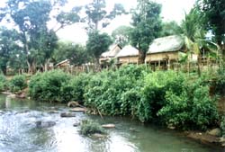
A sparsely populated province, it is renowned for its unique natural beauty and wealth of natural resources. The physical and environmental characteristic of the province forms an impressive range including undulating hills and mountains, a level plateau, watershed lowlands, crater lakes, rivers and waterfalls. Forest cover varies from area to area, from the dense impenetrable forest in the northern reaches, which are still rich in wildlife, to the drier and sparser forest, found in the southwest. Similarly, the soil types present range from rich volcanic soil to the sandy soil found near rivers.Thus Ratanakiri province offers wonderful opportunities for Eco-tourism in Cambodia.
Day 1:welcome guest at Ratanakliri airport and transfer to Hotel, city tour, Phnom Eisey Patamak, have a swin at Yeak Loam Lake, visit culture center, overnight.
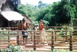
Day 2:Visit Ceal Rumplan ( stone field ), continue to Veun Sai district, take a trip along the Sre San river stop at Kachoun village, visit Tumpoun village, return journey through Ou'lalay, visit Kavet minority Chinese village, Banphang village, get the cotton yarn wrish tied and get water spray from elderly villages, visit Norng Kabat forest, turn back to Banlung, overnight.
Day 3:take a trip to Andoung Meas (Golden wells ) district, continue by boat to Taing Se commune along Sre San river, visit Charay hill tribe, visit gem mines and digging wells at Bar Kaev, on the way back, visit rubber plantation, coffee orchard, return to Banlung overnight.
Day 4:( Jan - May ) Transfer to Lumphat district, take a bath at Sre Pork river, visit Lao village, visit Cashew farm coffee orchard at Ou'cheng, Kachanh and Katieng Waterfalls, return to Banlung.
Day 5:Take a trip to Ou'Seanlair Waterwall, visit gem mines and digging wells, visit Tumpuon village and return to Banlung, overnight.
Day 6:Shopping handicrafts, fly back to Phnom Penh.
Ratanakiri is scarcely populated, and it is also true that the capital city does not have an adequate market, but if we can conclude that Ratanakiri abundantly possesses a variety of natural resources, they could then satisfactorily served as important elements to develop the national economy. Underground and on land resources are gold, mine, gem stone, granite, onyx, fertile red soil, water sources ( home of wild animals ), luxury and quality wood and above all, the beautiful weather with fresh and pure air, and yearly rain.
V . Transportation
By air :Now is not available.
By land : (636 km)from Phnom Penh - Kampong Cham - Kracheh (Overnight ), continue to Rattanakkiri by car. From Phnom Penh to Steung Treng by boat in raining season (Overnight) , continue to Ratanakiri by plane or car.
The popular kinds of transportation in banlung ( Ratanakiri ) are car, motorbike, elephants riding, boat or trekking.
VI. Population and ethnic Minorities Ratanakiri Province number 94,243.
The minorities represent 75.77 % of it.
|
1. Population: 1.1. Disabled persons: 1.2. Density: 2. Ethnic Minorities
|
|
VII. Climate
Ratanakiri Province has a climate like the other areas in the country, there are 3 seasons :
- Rainy season:June - October
- Cool season:November- February
- Hot season: March- May: Temperature: from 20o-32oc
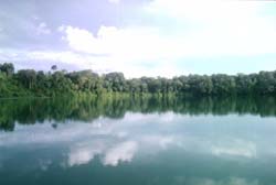
1.Yeak Loam Lake
Yeak Loam Lake is situated 5 km. south - east of Banlung. The Yeak Loam lake (volcanic crater) is the most beautiful lake of Ratanakiri formed by a volcanic eruption almost 4,000 years ago with 50 m. deep, 800 m. diameter and a walking path around the lake of 2,500 m. Two hundred meters of the track is a quaint wooden building housing tribal handicraft, the Crafts Museum.
2. Eisey Patamak Mountain
At the top of Phnom Svay is the statue of a reclining Buddha, situated 2.5 km. Awesome and peaceful, it has lain undisturbed throughout the years. Cast your eye outwards to glimpse Laos in the north and Vietnam in the east, and enjoy the spellbinding serenity of the surrounding countryside.
3. Kachang Waterfall
Kachang Waterfall is situated 6km. north - west of Banlung. This Waterfall is located in the Kontung stream and flows into the Sre Pok River. The height of it is 12 m. and the water flows and falls throughout the year. A beautiful or magnificent landscape and huge amounts of fresh mist surround the waterfall. The visitors can take a bath and sit to look at the waterfall and other natural scenic beauties. or the visitors can also go around to view other natural sights on foot or take an elephants ride.
4. Katieng Waterfall
Katieng Waterfall is situated 7 km. north - west of Banlung. It is also located in the Koutung Stream, below the Kachang Waterfall, 3 km. The height of it is 10m. and the water flows and falls throughout the year. The visitors can see a beautiful natural landscape and take a break to take pictures of the birds and then continue to the waterfall.
5. Ou'Sean Lair Waterfall
Ou'Sean Lair Waterfall is situated 26 km, South of Banlung. This Waterfall has 4 floors and the height of each floor is 4 m. The water flows throughout the year. Around the Waterfall are beautiful natural landscapes and the visitors can go take a bath if they wish.
6. Ou'Sensranoh Waterfall
Ou'Sensranoh Waterfall is situated 9 km. south of Banlung. The height of it is 18m. and the water flows and falls all the time. The visitors can go there rest and enjoy the fresh air, or to se the forest and listen to the birds ' cries.
7. Cha Ung Waterfall
Cha Ung Waterfall is situated 8 km. west of Banlung and it flows throughout the year. The source of water creating this Waterfall flowed from Eisey Patamak Mountain ( Svay Mountain ) . Below this Waterfall is a big hole, visitors can stand or sit to watch the waterfall from behind, and inhale he cool fresh air stemming from it .
8. Veal Rum Plan (stone field )
Veal rum Plan (stone field ) is situated 14 km. North of Banlung. Stones cover the surface of this place and a dense around it. The visitors can go there and discover its beautiful attraction
9. Virachay National Park
Virachay National Park is situated 45 km. north of Banlung. With a total land area of 332,500 ha. It has varieties of plants and trees in the forest and many different kinds of animals and birds.
10. Lumphat Wildlife Sanctuary
Lumphat Wildlife Sanctuary is situated 37km. south of Banlung. With a total land area of 250,000 ha. there are special kinds of animals and birds like tigers, elephants, red-headed vultures.
11. Ou'Chaloy
Ou'Chaloy is located in the Sre Pok river It is situated 34km. south - west of Banlung. The tourist recreation in Ou'Chaloy is only during the dry season.
12. Norng Kabat Forest
Norng Kabat Forest is situated 23 km. north of Banlung. This place has a pond. the visitors can go there to see the animals and birds which comes to at the pond .Beside this the tourists can go visit the ethnic villages, ethnic culture (tradition belief, festival, dancing, music),
IX. Shopping
A shopping spree starts at the Banlung market. Shopping bargains can be found on intricate stone, wood carvings, gem stones and other varieties of goods, many brought in by tribes like baskets, crossbows, gourds (water containers), bracelets, necklaces, cloth pipe from the outskirts of town make for an interesting and very colorful morning stroll.
Read more about Rattanakiri Province
More Articles on What To See

Angkor Complex

Phnom Penh City

Sihanoukville - Beach

Mondulkiri - Minority

Rattanakiri - EcoTourism

Kampot - Sea Foods

Kratie - Dolphin

Kampong Thom

Battambang

Preah Vihear

Kirirom Resort

Banteay Chhmar Temple
Cambodia Tours

Cambodia Day Tours

Angkor Temple Tours

Cambodia Classic Tours

Promotion Tours

Adventure Tours

Cycling Tours
Trip Planner
Useful Links
Travel Services
News & Media
Agency offering information about Cambodia on tourism, culture, history, visa, attractions, province guides, trip planner, hotels, flights, cars, tours, news, photo and online bookings.
#262D, Monivong Blvd., Sangkat Beung Raing, Khan Daun Penh.Click here to contact us.